One really neat thing about being a doctoral student in the Department of Geosciences is getting the opportunity to participate in projects that involve traveling to other parts of the state and doing science. I have been to the piney woods of Mississippi only once before, when I went with my Graduate Studio 2 class (in Landscape Architecture) to visit the studios of the late Ed Blake, Landscape Architect, in Hattiesburg. Before moving to Mississippi I read
Looking for Longleaf: The Fall and Rise of An American Forest by Lawrence Earley, an excellent and thorough description of the natural and cultural history of the longleaf system and an informative introduction to the challenging dynamics of landscape level ecological conservation. Earley's book describes the various impressions that the vast pine savanna made on the first European visitors, whose descriptions of the landscape as spooky, lonesome, and desolate alternate with expressions of admiration for its peaceful, verdant beauty. You can find some good information about the longleaf system
at this website from the NRCS.
My chance to return to the piney woods came about when I agreed to help another graduate student set up an experiment that involves measuring soil moisture in a catchment of the Black Creek in the
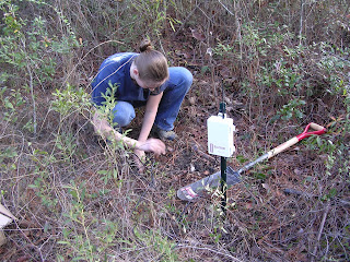
De Soto National Forest. We installed a datalogger that receives soil moisture data by radio from five moisture readers every 12 hours. Each reader is connected to two probes, so the data logger is receiving information about ten discrete spots in five separate locations. Cheryl, the student researcher, plans to come to the site once a month to collect the data from the logger. The logger also has a rain gauge.
On the way down we stopped at the NRCS service center in Meridian and I noticed this sign for the
Lauderdale Agri-Center, an equestrian facility managed by Lauderdale County next door. I snapped this photo for a sense of place: Lauderdale County is not afraid of the Name of Jesus.
This is the forest in which we spent the day. Here is a mature longleaf pine next to what I believe is a shortleaf pine (but could be loblolly). The forest is a mix of different pines and longleaf is by no means dominant. The understory is mostly yaupon holly, inkberry holly, and wax myrtle. It also features various small oaks (I call them turkey oaks), bay magnolia and various species of
Vaccinium, including the quite large sparkleberry (
Vaccinium arboreum) along the stream bank. I think I saw some anise (
Illicium parviflorum) but I am not sure. We found plenty of blackberry and some (infrequent) Japanese honeysuckle. We saw the evil Cogon grass on the roadside as we drove in, but none in the area in which we were working. It is a wonderful landscape to hang out in, especially on an unseasonably warm and sunny day as we had.
Longleaf pine spends the first several years of its life as a short, bristly shrub as seen in this picture. The needles insulate the cambium from the fires that were frequent before European settlement. Under a natural fire regime, all of the groundstory vegetation mentioned above would be replaced by grasses and forbes.
We dug a hole in sandy soil on the ridge top to place the data logger. As you can see it was in several pieces and we assembled it on site. Cheryl is using the GPS on her phone to get the lat/long coordinates.
Here the data logger is assembled, receiving power from the solar panel and receiving soil moisture information from the probes. Cheryl can confirm that all is working properly by logging the data in her laptop.
Here is one of the soil moisture readers installed a few hundred meters
from the data logger. It sends the data from the two probes to the data
logger by radio. The manufacturer claims that the signal range is three
miles. We did not test it that far. At each site we took a soil sample
with a large auger and Cheryl identified the soil type.
These last two shots are of the
Black Creek, a federally designated wild and scenic river. USFS manages a trail and some campsites along the stream. It is a floatable river, and
a local company offers canoe rentals. I was very impressed by the white sand on the banks and on the natural levees. I was also impressed by how much more birdsong I could hear down in the creek compared to on the ridge top. The stream is on the northern edge of the National Forest, but the area is undeveloped. The entire day I heard no traffic (except one or two cars), no airplanes, nothing but the wind and a few birds. Down in the creek I heard the water gurgling, both a deep woofer gurgle and the treble notes of the riffles. And woodpeckers. I plan to return with the family and maybe some innertubes when the weather gets warmer.


