Sunday, August 21, 2011
Some good news about walkable urban space.
Woke up to an interesting story on NPR's Weekend Edition Saturday yesterday. Host Jacki Lyden interviews Chris Leinberger, a member of the Brookings Institution and Director of the University of Michigan real estate graduate studies. They discuss the recent announcement of the bankruptcy of Border's Books and the immanent closing of nearly 400 stores. Leinberger says that retail shops in drivable suburban spaces don't fare well when they lose an anchor store. Retailers in walkable urban spaces fare much better. The pendulum is and has been swinging towards walkability. Developers realize that we have overbuilt drivable suburban retail and there is a pent-up demand for walkable urban retail, which can actually be (and has been) built to replace the former in suburban areas. Leinberger cites Belmar in southwest Denver as an example of a suburban stripmall that was razed and replaced with a walkable street grid, and Reston Town Center as a walkable greenfield development ("the best one in the country") outside of Washington, D. C. Now I've told you so much about the piece you hardly need to make the jump.
Thursday, August 18, 2011
Urban Context of the previous post
Here are two aerial images of the building I wrote about yesterday in the context of the surrounding town of Starkville, Mississippi. You will want to click on them to get a larger version in order to really appreciate them. The source for the top image is the National Agriculture Imagery Program (NAIP). It was taken in 2009 during "leaf on" conditions. The yellow circle marks the location of the building being remodeled (the subject of yesterday's post). North is up, and the Borden plant is just across the road to the south. The 2009 image shows the construction taking place at the Borden Plant.
I don't have a source for the bottom image. It was given to all students in a landscape architecture class I took in 2008. If we were given the source I did not preserve it. The image used here is clipped from a much larger image of the town and the Mississippi State campus. The original image shows malfunction junction near the Davis Wade stadium at Scott Field. "Malfunction junction" at MSU is worth a blog entry itself. The presence of this feature means that the image was taken in early 2005 or earlier, since the intersection was demolished in the summer of 2005 and replaced with a an area of open turf and walkways now known simply as "The Junction". The earlier picture, taken in "leaf off" conditions, allows more details of buildings to be seen. You can see how much of the Borden Plant was removed during renovation. The plant had an entire wing right next to the water tower.
Downtown Starkville is in the left part of the image, the western edge of the Cotten District is visible to the right of the cemetery.


Wednesday, August 17, 2011
Something Good in Starkville
In a post last year I criticized an award-winning development on the corner of Lynn Road and South Montgomery Street here in Starkville for the fact that it features a nine-foot high block wall around it, completely rejecting the street and the corner on which it is situated. Today I would like to praise a building renovation on another highly visible street corner in town on the corner of Lampkin and South Montgomery Streets. So many new places in town reject the street completely, but this old house renovation, a property owned by Rick Underwood of Rick's Furniture on Stark Road, destined to become a specialty furniture boutique, acknowledges and embraces the corner, the street, and the sidewalk, both aesthetically and functionally. Also, the design and construction are of very high quality. The contractor is Chad Yost. The porch enhancements, and particularly the arbor which reaches out to incorporate the public, pedestrian space, are very well done and demonstrate the touch of a property owner and contractor willing to go the extra mile.

Approaching the new renovation from the south, the weedy lot to the left is the site of a town-owned water tower and is sometimes a storage area for equipment and materials for the development of the old Borden Plant. The fairly new Central Station Grill is in the Borden Plant building on the southwest corner of the Lampkin/South Montgomery intersection. The Grill at least acknowledges the street corner, but doesn't attempt to do anything with it.

A closer look at the building, still approaching from the south on foot. I have always wondered why this intersection, in the middle of town, is not signal controlled. On the one hand I like the four-way stop, because it causes all motorists to pay attention to one another. On the other hand, the railroad tracks bisecting the intersection diagonally cause the eastbound traffic to have to stop on a line 30-40 feet before the actual intersection. Motorists moving in other directions have difficulty determining whether those cars have actually taken their turn stopping or not. Every other four-way intersection for several blocks in any direction are signal controlled.

Getting closer still. The little sidewalk going off to the left is The Grill's attempt to incorporate their landscaping into the pedestrian infrastructure. At least they tried.

A work of art in progress, seen from the opposite corner.

Front facade. According to Mr. Underwood, much of the wood that was removed during remodling was reused. The antique brick that was removed when the old steps were taken away is stacked neatly on the side of the building and will be used for a patio between the front porch and the sidewalk.

East side.
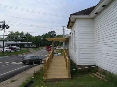
Handicapped access.

Entrance as seen by pedestrian coming from the west.

My panorama of the Central Station Grill and the Borden Plant on the corner across the street. Too bad the sidewalk dies when it gets to the train tracks. I see a lot of pedestrian traffic here. We are a block from Main Street and about two blocks from my house. The landscaping uses quality material and is well-maintained, but design-wise is more evocative of strip-mall than a downtown place to eat in a historic, industrial building. Overall, though, the developers of the Borden Plant are doing it right. The Grill is a spacious, comfortable and attractive space in which I really enjoy eating, and Boardtown Bikes is a great addition. They plan to add condos: read about it here. I hope it happens.

Meanwhile, five blocks south on the same street...
Sunday, August 14, 2011
Sunday Morning at NWR


Nothing fancy, just a mid-August Sunday outing to the Noxubee Wildlife Refuge with some children. In the spirit of Last Child in the Woods: Saving Our Children from Nature Deficit Disorder by Richard Louv, we take the kids out to the wilderness as often as possible so that they might grow up to value natural areas.
The water in Bluff Lake was low, so we were able to walk out among the cypress knees. Saw a bald eagle flying over the lake as we drove in. Not much blooming at the Morgan Hill Overlook, just some mountain mint (white) and partridge pea (yellow in the top picture). They burn that meadow every January, which is too often if you ask me. They should let it grow for three or four years and build up some diversity. In the roadside ditches we saw ironweed and goldenrod. The Callicarpa has berries starting to show some color.
Theodore Roosevelt Island National Memorial
One highlight of our recent trip to the District of Columbia was a visit to the Theodore Roosevelt Island National Memorial. Here is GE shot of the Island in the urban context, with Arlington, VA on the left (west) and the Lincoln Memorial and part of the National Mall recognizable on the right.

Aside from the Memorial Space, the fountains of which had been drained and were under repair, and a trail system, the island appears natural and undeveloped and is a peaceful and shaded contrast to the surrounding cities.

In the above picture our dog is swimming in the channel near the northwestern corner of the island, with the buildings of Arlington rising above the trees of the river buffer. For her, this excursion was a welcome break from the highly recommended downtown dog boarding facility where she spent most of her time.

This image shows a debris jam on the eastern side of the island and a view across the main channel of the Potomac River to the Washington side. Walking around on the island one gets a feeling of being in just about any eastern woodland forest miles from the city. The picture below could have been taken at Duke Forest or Eno State Park in Piedmont North Carolina. We saw a turtle at the southern end of the island in the estuary and two deer in the woods on the ridge in the middle of the island.

The park features extensive woody wetlands containing the non-native yellow flag iris and the indigenous Sagittaria latifolia, or broadleaf arrowhead. A boardwalk traverses much of the wetlands. There are also marshes and an estuary draining the island to the south. Signage indicates that although the system is too far from the Atlantic Ocean for salt water to be of any influence, the level of inundation is affected by tides.


Your humble narrator poses at an estuary observation platform. A three-shot panorama stitched in PhotoShop. You can click on the image to open a larger version, and click again to make it even larger, and look for the seams, but you won't find them.

A four-photo wide shot of the estuary stitched in PhotoShop.

An unusual view of the Lincoln Memorial under the Theodore Roosevelt Memorial Bridge.

An interesting "room" under the Theodore Roosevelt Memorial Bridge.

The route we took mapped in Google Earth. The park was used extensively by joggers throughout the day and into the evening. We were able to park on the Arlington side and walk across a pedestrian bridge (visible in the middle of the western channel in this aerial image) to get onto the island. The residents of Arlington and the district are fortunate to have such a large wilderness area in such proximity in the form of a national park. In Starkville terms, it would be like having the Noxubee Wildlife Refuge as a five minute walk from campus. Such a thing is still possible: South Farm has potential wilderness area and there are various undeveloped or blighted areas all around town. Oh but such thoughts are mere dreams buffeted by the flimsy tubes and html codes of the internet.
Subscribe to:
Posts (Atom)