Wednesday, April 25, 2012

Controlled Burn South of Campus

This semester I have been auditing a class in prescribed fire taught in the Forestry Department. It is an undergraduate class with no graduate section. I learned a lot, and I encourage landscape architecture students, and any student interested in landscape ecology, fire ecology, or fire effects, to take the class. This class gives the student an opportunity to examine how climate, weather, physiography, and forest types interact, not just in general (as in an ecology class), but in terms of a specific disturbance pattern: fire. I found that I was able to focus much more intently on weather processes when viewing them with a specific application in mind rather than for the sake of the processes themselves. In order to effectively burn a unit of land, that is, to burn it in order to achieve specific management goals, a certain set of conditions must be met. Fuels can't be too wet, but they can't be too dry either. Air has to be stable - high winds can spread the fire out of control - but not TOO stable: stratified air won't allow the smoke to rise.

The second half of the course involves developing a burn plan for a specific parcel. The burn must have a goal. The effects, especially smoke effects (since smoke is mobile) on neighboring areas must be considered. Everything needs to be mapped: the site itself, and the site in the context of the landscape matrix. In this way, the class is much like a landscape architecture studio course but with a twist: a lot more attention is paid to weather and the design intervention amounts to a human-produced imitation of a natural disturbance.

Part of the class involves participation in a prescribed burn. All semester the conditions were not good, but finally, on the last week of class, the MSU forest supervisor was able to plan and get a permit to burn a 40 acre unit in the John W. Starr Memorial Forest. Students were notified the day before by email and were told to arrive at the classroom at noon with hardhats, boots, and safety glasses.

We arrived at the unit about half past twelve. The temperature was about 71 degrees Fahrenheit with relative humidity about 34%. Wind was from the west at about 4 miles per hour. The purpose of the unit is production of saw timber. The purpose of the burn was to reduce hazard fuels. The hazard fuels were understory trees and vines. From my observation walking through this consisted mainly of maple, sweetgum, hickory, and a lot of smilax (greenbriar) and vitis (muscadine or scuppernong grape, I can't tell them apart).

So here are the photos. As always, if you want more detail, click on them and they get bigger.


This road is the east boundary of the unit. The view is southwest. The unit is a square quarter of a quarter section. The backing fire was set first along this east boundary, about an hour before we arrived. A backing fire moves slowly into the wind.

 This is the fire lane that was plowed along the north boundary.


Our professor showing us the disc that was used to plow the fire lanes. Since the unit is bounded on three sides by roads, only the north side needed a plowed lane. The crew had added an extra lane running east-west in the center of the unit.

 We walked along the north boundary and observed the backing fire. There wasn't much to see. Flame height was about a foot and it was advancing slowly. The above is a three-photo panorama hastily snapped and stitched of the students and some of the fire crew on the north side watching the backing fire. Smoke is blowing away from us to the east.

The burn crew gave us a drip torch and we all entered the forest about fifty feet beyond the front of the backing fire to set a strip head fire. The professor carried a compass to ensure that we stayed on a due-south line. The flaming front of the strip head fire moves with the wind to meet the back fire. Even though the wind was very light (imperceptible to me in the forest interior), the strip head fire behaved quite differently than the backing fire. Flames were much higher and it moved faster. Going was rough in the interior: lots of smilax, vitis, and small hardwoods.


The strip head fire consumed a lot of the smilax and  vitis and the needles draped among the vines. Where these fuels were thick, the fire actually roared and hissed.


We paused in the fire lane at the halfway point to watch the strip head fire approach the backing fire. This is another hastily snapped and stitched three photos of the strip head fire we just set.We then continued south setting fire to the woods. The underbrush here was even thicker than before.


A student with the drip torch.


Here is one of the more dramatic shots of the strip head fire. After we emerged on the south boundary, we lit up the rest of that, then moved north along the west boundary, setting it alight as the final head fire of the day.

It looked to my inexperienced eyes like a fairly successful understory burn. We observed that not all of the duff was consumed, just the top layer. The soil was undamaged. But most of the smaller maples, sweetgum and understory trees were top-killed by heat girdling. Many of these will resprout from the roots, but their above-ground mass is gone for now. Better browsing for deer.

Again, I encourage landscape architecture students to take a prescribed burn class because it brings out the details of the natural environment in dynamic interaction. Also, "certified burn boss" looks good on a resume. At least it does to me.

Saturday, April 21, 2012

Google Earth Helps Orphan Find Birth Mother

I have not been keeping up with my blog, and that is not good. My school-related tasks have been formidable. In March I took my comprehensive exams (I wrote for five days and produced a 20,000 word document), and last week I defended them. I am also taking classes in Prescribed Burning and Linear Regression. But I resolve again to pay more attention to this blog. I am never short on ideas.

This morning I came across an interesting article in which Google Earth helps an orphan find his home village. A five-year old boy working with his older brother sweeping trains and stations in India fell asleep on a train station bench. When he woke up, he could not find his brother. He saw a train and assumed his brother was on it, so he got on. His brother was not on the train. He fell asleep again and woke up in Calcutta fourteen hours later. He did not know the name of the village in which he lived and had no way to get back, at least not until 25 years later. You can read the rest after the jump, but it involves Google Earth (one of my favorite topics), and the basic GIS principal of using time and distance to calculate a buffer.

Sunday, February 19, 2012

An Open-source Civilization Starter Kit

This was a nice story to wake up to this cold and wet Sunday morning. File under "people changing the world." Marcin Jakubowski gets a Ph.D. in physics and decides to start a farm on thirty acres of land. When his tractor breaks, he doesn't take it to the tractor place, he gets a welding torch. After messing around with the welding torch for a while, he builds a tractor of his own."A tractor is basically a solid box with wheels, each with a hydraulic motor," he says. He starts thinking about the fifty most important machines for civilization and how to make them. This leads to participation in The Open Source Ecology Project,  a network of designers and engineers developing open source access to detailed plans on how to build these fifty machines at a fraction of the cost of buying them from established manufacturers. They call this the Global Village Construction Set. One of the machines makes bricks out of dirt. Jakubowski becomes a fellow of TED, the nonprofit purveyor of popular videos about new ideas in Technology, Entertainment, and Design. You can see his TED video here. A quote: "Our goal is a repository of published design so clear, so complete, that a single burned DVD is effectively a civilization starter kit...if this idea is truly sound, then the implications are significant. A greater distribution of the means of production, environmentally sound supply chains, and a newly relevant DIY maker culture can hope to transcend artificial scarcity."

This ideas are not new. I grew up in a house that had more than one Whole Earth Catalog or CoEvolution Quarterly laying around. Is Jakubowski just another voice in the conversation put forward mid-century by folks like Gary Snyder and Stuart Brand? Different factions of the back-to-the-land movement have different attitudes about technology. I remember a fellow from the North Carolina mountains (whose name now escapes me) who used no gas-powered machinery on his farm. I like Jakubowski's presentation and the NPR article because I think they get the technology just right: using the digital component of the wiki in order to better distribute access to the best products of the industrial age, such as ovens, windmills and circuit boards. Why am I writing it up in a blog devoted to landscape architecture and geospatial science? Because planning human affairs in space at the landscape level is fundamentally about distribution, and that is the focus of Jakuboski's presentation. That is why the aerial shot of the village is so effective at the end of his talk.

Monday, January 16, 2012

Thoughts on Orange Beach Alabama


Everything I observed in Orange Beach, Alabama was colored by my experiences as a frequent visitor to the North Carolina coast and to the Brunswick County beaches in particular. In North Carolina high rise condos are rare. A quick internet search revealed only two: Grand Villas in Indian Beach and Atlantic Towers in Carolina Beach. Most developed beaches in North Carolina feature family beach cottages, the largest usually three stories, usually behind the first dune. Also, in North Carolina, the “dry sand” area (from high tide to the dunes) of all beaches belong to the public. The “wet sand” area and the surf belong to the state. It is impossible to privately own a beach in North Carolina, although developers and individuals try to get around this law from time to time. One such case is Figure Eight Island. The entire Island is private and can be accessed by car only by crossing a guarded causeway bridge. Uninvited guests can only walk the beach after swimming across the short inlet from Wrightsville Beach. Here is a good description of North Carolina’s public beach law, with references.

In South Carolina gated communities are allowed to have exclusive access to a beach, most notably in Hilton Head. I have visited beaches in Myrtle Beach that were nominally public, but the pattern of private ownership and road networks allowed no place for the public to park. North Carolina, or at least Long Beach, where I often visit, does a good job of distributing small public parking lots among the private parcels.

In an hour of internet searching, I was unable to find much real information about the beaches of Alabama, Mississippi, and the Florida panhandle. Is it possible to privately own a beach on the US Gulf coast?  Some developments (such as Romar House, which I will get to later) use the term “private beach” in their advertising, but the real meaning is unclear. And I assume some renourishment is ongoing, but how much and how often?

The Florida Department of Environmental Protection extols the benefits of beach renourishment, but does not give details about where and how often it is carried out.

The Alabama Department of Environmental Management appears to be the primary management agency for the beaches in that state, but their website presents no information about renourishment and focuses primarily on water quality issues. Here is another opinion about beach development and renourishment from the infamous coastal geologist Orrin Pilkey.

 My wife and I took our kids and spent New Year’s Eve weekend in Orange Beach, Alabama. The oceanfront of Orange Beach consists almost entirely of high-rise condos, with perhaps a half dozen beach cottages in the mix, along state highway 182. Just beyond the chain of strip malls on the inland side of the highway lies the 6,150 acre Gulf State Park. The Park punches through to the beach at two points along the strip of condos, and at the western point the Park runs along the beach for two entire undeveloped miles. Gulf State park provides not only ample parking for the public, but showers and bathrooms as well.

We stayed at a very affordable condo at the western end of Cotton Bayou adjacent to the other (eastern) Gulf State Park beach access. The Bayou is connected to the Gulf of Mexico by Perdido Pass, not far from the AL/FL state line. One day we saw a dolphin splashing in the bayou. We also saw great blue herons and an Osprey.

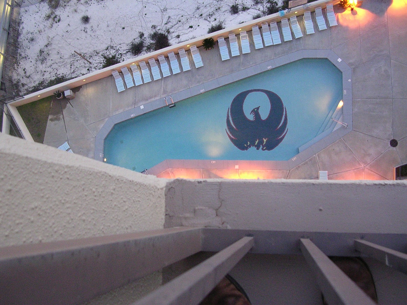
We visited friends who were staying at the Pheoxix IV condos, in the middle of the strip. Here is a picture of the swimming pool from the balcony of the fourteenth floor.

 When I saw this, I was immediately reminded of the logo for the Rebel Alliance from the Star Wars movies:
This image of Luke Skywalker comes from a website devoted to Star Wars helmets.

Most of the condos left exterior lights on after dark. In North Carolina, this is a big no-no, as it confuses the sea turtles. Even if the sea turtles came ashore, however, they would not have access to the dunes, for they were all fenced off. But the turtles did of course have easy access to the two miles of beach at Gulf State Park, just down the road.

Here is a picture of the afore-mentioned Romar House, just next door to the Phoenix IV, at dusk. Note that the exterior lights are on. But also, more noteworthy to me anyway, is the sign, several meters out from their boardwalk, claiming the beach as private property.

 And here is a shot of the same sign in context from above, with some children (some of whom are my children) included for scale:
So whose beach is it?

I don't have anything against beach condos, really. I suppose their density allows more people to experience the beach than is the case in North Carolina. I marvel at how they stay in place that close to the water. Why don't they sink? This was only my third trip to the Gulf Coast and I probably got a few things wrong in this report. I look forward to going back and learning more about the area.

Thursday, January 12, 2012

More Thoughts on Google Street View

I don't play video games, unless you count Google Earth Street View. For me, GESV is a fun way to explore landscapes and think about configuration and form. The quest for images with strong composition and interesting subject matter is a scavenger hunt. The moment of discovery is the reward. In rural areas, I am looking for interesting forms. In urban areas I am usually looking for life in the street, which usually means people. One of the principal problems discussed in Landscape Architecture is how to bring life to the street. Designing cities for people is the focus of New Urbanism and groups like The Project for Public Spaces. In our landscape architecture classes we discuss walkability, sense of place, and read a lot of stuff by Peter Calthorpe, Andres Duany and Kevin Lynch. It's all about people in public space and the human experience of spaces. Generally, nice photographs of public space or street space features lots of people experiencing the space. In Landscape Architecture magazine, Landscape Architects become perplexed when the public fails to utilize a well-designed space or when a poorly designed space gets a lot of use. I remember a particular example of a simple field of artificial turf, but I don't have time at the moment to track it down.

Google Earth Street View shows you the other side, the reality (of a sort). Drop in from the Google Earth Eye of God into any street grid and chances are you will find it empty. If you peruse randomly, it could be a very long time before you see any people at all. If you do this often enough, you develope a sense of what configuration of streets are more likely to yield human forms. Grid or wagon-wheel configurations, usually indicating the oldest part of the city, are generally better candidates. The professors always tell us "pay attention to the corners," and this holds true in GE, especially corners near open space. Areas along rivers, or, more likely, a block or two from the river, are good candidates. I believe GESV could be used in an exercise in a Landscape Architecture class. The instructor could present the student with a short list of things to find: somebody sitting down, somebody on a bicycle, a child under twelve, etc. The student would learn to recognize from the air how to "read" the landscape, find the mass transit system, the arteries, and the nodes.

Here is a blog in which someone has found a little story in the street in GE Street View. A woman is walking and trips and falls. If you look closely, you can see the chunk of rock that she tripped on. She stays on all fours for a moment but eventually stands up. Yesterday you could see her quite clearly, but today, perhaps because the internet found out about her, it appears that Google has pixellated her. More interesting (to me anyway) is that this is a street with a surprising amount of life in it. In fact, if you continue down the street, you find eleven more people sitting on the sidewalk. They appear to be a little scruffy, as if sitting on the sidewalk is about all they have been doing and all they intend to do for the day. Some of them are watching the woman trip and fall. It is a little vignette played out on a street in Brazil. Perhaps not exactly the kind of 'life" the urban planners want, but it is alive.

Tuesday, December 27, 2011

More Google Earth Street View Images

Sometimes at the end of the day I like to take a break and tour the world via Google Earth Street View. Harvesting Street View images is an idea I got from Jon Rafman, the grand master. It's hard to explain why I like doing this so much. I sense a thrill of discovery, also a drive to explore the world, to understand geography, sense of place, and also to identify interesting material and then compose the shot. I use minimal zooming functions and no photo retouches. I previously posted a collection of harvested images last march. Several months later, I have a new batch. I've been to the Brazilian countryside, the north coast of Norway, Romania, some bedroom community of Denver, the cathedral at Reims, and Baltimore. I could try to talk you through them, but I think it is more fun to mix them all up like a deck of cards and just let you at them. However, I can't resist a few captions. As always, if you want 'em bigger, click on 'em.


My OCD is mad that I did not center this one better.

In the television series "The Wire," these abandoned row houses are sometimes portrayed as metaphorical tombstones. In Street View, I peruse them hoping to find something interesting in the open windows. A home run would be a person looking back. I found these pigeons in one and said "that'll do!"
Many many blocks of these abandoned row houses can be found in Baltimore.

You might guess Baltimore but this is actually Philadelphia.
The Center of the World.

Not sure what's going on here but they seem to have more dirt than they need.
This is their front yard, where they hang out. What makes this picture really great is the fact that there is something green in the planter.


Automatic face blur working one third of the time here.

Campfire site at the end of a road in Norway.


Friday, December 23, 2011

A Day in Longleaf Country


    One really neat thing about being a doctoral student in the Department of Geosciences is getting the opportunity to participate in projects that involve traveling to other parts of the state and doing science. I have been to the piney woods of Mississippi only once before, when I went with my Graduate Studio 2 class (in Landscape Architecture) to visit the studios of the late Ed Blake, Landscape Architect, in Hattiesburg. Before moving to Mississippi I read Looking for Longleaf: The Fall and Rise of An American Forest  by Lawrence Earley, an excellent and thorough description of the natural and cultural history of the longleaf system and an informative introduction to the challenging dynamics of landscape level ecological conservation. Earley's book describes the various impressions that the vast pine savanna made on the first European visitors, whose descriptions of the landscape as spooky, lonesome, and desolate alternate with expressions of admiration for its peaceful, verdant beauty. You can find some good information about the longleaf system at this website from the NRCS.

     My chance to return to the piney woods came about when I agreed to help another graduate student set up an experiment that involves measuring soil moisture in a catchment of the Black Creek in the De Soto National Forest. We installed a datalogger that receives soil moisture data by radio from five moisture readers every 12 hours. Each reader is connected to two probes, so the data logger is receiving information about ten discrete spots in five separate locations. Cheryl, the student researcher, plans to come to the site once a month to collect the data from the logger. The logger also has a rain gauge.

On the way down we stopped at the NRCS service center in Meridian and I noticed this sign for the Lauderdale Agri-Center, an equestrian facility managed by Lauderdale County next door.  I snapped this photo for a sense of place: Lauderdale County is not afraid of the Name of Jesus.

This is the forest in which we spent the day. Here is a mature longleaf pine next to what I believe is a shortleaf pine (but could be loblolly). The forest is a mix of different pines and longleaf is by no means dominant. The understory is mostly yaupon holly, inkberry holly, and wax myrtle. It also features various small oaks (I call them turkey oaks), bay magnolia and various species of Vaccinium, including the quite large sparkleberry (Vaccinium arboreum) along the stream bank. I think I saw some anise (Illicium parviflorum) but I am not sure. We found plenty of blackberry and some (infrequent) Japanese honeysuckle. We saw the evil Cogon grass on the roadside as we drove in, but none in the area in which we were working. It is a wonderful landscape to hang out in, especially on an unseasonably warm and sunny day as we had.

     Longleaf pine spends the first several years of its life as a short, bristly shrub as seen in this picture. The needles insulate the cambium from the fires that were frequent before European settlement. Under a natural fire regime, all of the groundstory vegetation mentioned above would be replaced by grasses and forbes.


We dug a hole in sandy soil on the ridge top to place the data logger. As you can see it was in several pieces and we assembled it on site. Cheryl is using the GPS on her phone to get the lat/long coordinates.


Here the data logger is assembled, receiving power from the solar panel and receiving soil moisture information from the probes. Cheryl can confirm that all is working properly by logging the data in her laptop.


Here is one of the soil moisture readers installed a few hundred meters from the data logger. It sends the data from the two probes to the data logger by radio. The manufacturer claims that the signal range is three miles. We did not test it that far. At each site we took a soil sample with a large auger and Cheryl identified the soil type.


These last two shots are of the Black Creek, a federally designated wild and scenic river. USFS manages a trail and some campsites along the stream. It is a floatable river, and a local company offers canoe rentals. I was very impressed by the white sand on the banks and on the natural levees. I was also impressed by how much more birdsong I could hear down in the creek compared to on the ridge top. The stream is on the northern edge of the National Forest, but the area is undeveloped. The entire day I heard no traffic (except one or two cars), no airplanes, nothing but the wind and a few birds. Down in the creek I heard the water gurgling, both a deep woofer gurgle and the treble notes of the riffles. And woodpeckers. I plan to return with the family and maybe some innertubes when the weather gets warmer.